Tutorial Stream and Catchment Delineation using PCRaster in QGIS
1. Introduction
One of the most important uses of GIS in hydrology is the delineation of catchments and streams. This lesson presents a generic workflow for stream and catchment delineation for areas where only open data is available. The Shuttle Radar Topography Mission (SRTM) 1 Arc Second DEM will be used. The workflow will be applied to the Rur catchment in Germany.
After this lesson you will be able to:
- find and download SRTM DEM tiles from the EarthExplorer website
- mosaic raster layers into a virtual raster
- reproject rasters
- create subsets of rasters
- fill sinks in a DEM
- calculate and style flow direction raster layers
- calculate Strahler orders
- delineate streams
- delineate catchments
- style layers for visualising catchments
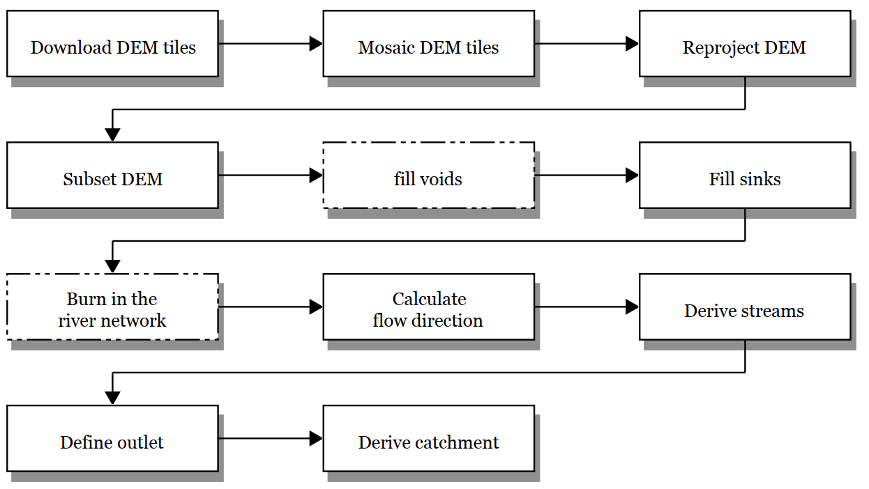
In order to delineate a catchment from a DEM in GIS we need to follow these steps (details covered in this lesson):
1. Download the DEM tiles of your study area. Make sure that the tiles cover at least the study area and that the catchment you want to derive is covered completely. Better to take it a bit larger to avoid boundary effects.
2. If your study area is covered by multiple DEM tiles, you need to mosaic (merge) the tiles to create a single raster DEM layer.
3. The DEM tiles might be in a different coordinate system then desired. In that case you have to reproject the DEM layer to the projection you want to use in the study area.
4. In the case that the merged tiles are much larger than your study area, you can subset (clip) it to a smaller area to reduce calculation time.
5. Interpolate voids when pixels with no data exist in the DEM.
6. Make a hydrologically correct DEM by filling sinks and removing spikes.
7. Calculate the flow direction for each cell.
8. Derive the drainage network.
9. Calculate the catchment for the outflow point of the catchment.
When a map with the stream network already exists, the procedure can be improved by "burning" the river network into the DEM. In that way the DEM is always lower at rivers and runoff will follow the actual river network. This is beyond the scope of this chapter.
The matrials for this lesson can be downloaded from the main lesson page. The next section covers how to download the SRTM tiles from USGS EarthExplorer. These are also included in the course data.