Tutorial: Stream and Catchment Delineation
Completion requirements
6. Fill Sinks and Calculate Flow Direction
6.6. Visualize Flow Direction in 3D
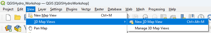
We can also visualize the flow direction using the QGIS 3D Map View.
1. In the main menu, choose View | 3D Map Views | New 3D Map View.
2. In the 3D Map view, click the Options
![]() button and choose Configure....
button and choose Configure....
3. In the 3D Configuration dialog, stay in the Terrain tab and change the Type to DEM (Raster Layer) and choose dem as Elevation. Click OK to apply the settings and return to the 3D Map view.
The 3D view will now start rendering. Try to navigate the scene with the different mouse buttons and the compass. You can change the Vertical scale, Tile resolution and Skirt height in the 3D Configuration to improve the visualization.
