
Besides vector data, we can also load raster data.
Let's add a high resolution satellite image.
1. In the Browser panel go to the MapTiler folder and click right on Satellite.
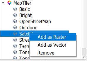
2. Choose Add as Raster from the context menu to add the Satellite image raster tile to the map canvas.
3. In the Layers panel, uncheck the box of the OpenStreetMap group to hide the OpenMapTiles vector tile and see the satellite image below.
4. Zoom in to see the details.